
Check Watauga ZIP Code Coverage
City-hosted records provide evidence for two ZIPs in Watauga: 76148 and 76137. That evidence is narrower than a definitive polygon for every street. The City lead-pipe analysis includes Watauga examples for Birchill Road in 76148 and Bison Trail in 76137. It is an infrastructure report, not a postal boundary ordinance. The table therefore identifies what the research could confirm and keeps the unconfirmed parts clear.
| ZIP | Watauga evidence | Postal point | Verification note |
|---|---|---|---|
| 76148 | Watauga core, City Hall and library on Whitley Road, plus city-hosted Birchill Road examples | Watauga Post Office, 6651 Watauga Rd Ste 103 | Used in Watauga addresses and surrounding Tarrant postal aliases; check each situs with USPS and the county map. |
| 76137 | City-hosted lead-pipe analysis has a Watauga Bison Trail example | Exact Watauga post-office assignment not located in official sources | It does not prove that every 76137 address falls within Watauga city limits. |
The City of Watauga lead-pipe analysis is the local source for the documented examples. USPS has not supplied a captured city-and-state output or official polygon for every Watauga address in this research. Treat the two ZIPs as verified record evidence, then confirm an individual address.
Follow a Watauga ZIP Code Workflow
A ZIP narrows an address question but does not generate an official Watauga residents list. The visible TAD search did not show a documented field that returns every parcel in a ZIP, and Tarrant GIS does not document a ZIP-based household roster. Use the postal result to format and verify the address first. Then use property and map tools one address at a time. That is more precise than assuming a postal label supplies a complete street or occupant list.
- Enter the full address in USPS Find by Address. Include apartment or suite detail when relevant, because USPS can return multiple unit results.
- Compare the USPS result with the Watauga city boundary map and the Tarrant GIS parcel view. Record the delivery assignment and municipal geography separately.
- Search the verified address in Tarrant Appraisal District by address, account, owner, or property type. Save the situs city, legal description, account, and subdivision.
- Use the GIS Address, Account, or Owner mode to inspect the parcel. Map records describe location and parcel attributes, not household membership.
- If the question becomes street-specific, continue with the Watauga street directory for the address-to-parcel and deed-record workflow.
For a public record held by the city, a narrowly written Texas PIA request can identify the address, record type, and date range. It is a request route for government-held material, not a way to obtain protected voter information, private utility data, or a universal list of people at a ZIP.
Define Watauga ZIP Code Terms
Postal, parcel, and directory labels have different jobs. Keeping their names straight helps when an older deed, an appraisal card, and a delivery result use different address forms. The research found no official evidence of a Watauga-only ZIP, a PO-box-only local ZIP, or complete carrier-route coverage. Those terms are still useful when reading an address record.
- ZIP versus ZIP+4
- A ZIP identifies a delivery area. ZIP+4 adds a more specific delivery segment and does not draw a city boundary.
- PO-box ZIP
- A ZIP used for post-office boxes rather than a claim that every street address is served by that label.
- Unique ZIP
- A ZIP assigned to a single organization or high-volume receiver. No Watauga example was verified in the research.
- Carrier route
- A delivery sequence used by postal operations. An individual route was not documented as a public Watauga boundary layer.
- Situs address
- The physical parcel location used by TAD and GIS, which can differ from the tax mailing address and USPS formatting.
Note: A postal result helps format or verify an address, but USPS states that it does not confirm a person or company at that address.
Use Watauga USPS ZIP Lookup Fields
The official USPS lookup offers three paths: Find by Address, Find by City and State, and Find Cities by ZIP. Find by Address is the best first check for an individual Watauga delivery address. It requires a street address, city, and state. Company, apartment or suite detail, and an existing ZIP are optional. If results return more than one unit, add the unit information rather than guessing.
| USPS field or tab | Type | Required | Use and format note |
|---|---|---|---|
| Find by Address | Tab | No | Address-to-ZIP mode. |
| Street Address | Text | Yes | Enter the delivery street address. |
| Apt/Suite/Other | Text | Optional | Use to narrow multiple-unit results. |
| City and State | Text and dropdown | Yes | USPS notes recognized city names. |
| ZIP Code | Text | Optional for address mode, yes for ZIP-to-city mode | Narrows an address or returns city information from a ZIP. |
| Results per page | Selector | Optional | 10, 20, or 30 results displayed. |
The USPS ZIP Lookup is the online verification channel. The Watauga Post Office at 6651 Watauga Rd Ste 103 is the local postal landmark for 76148. Its displayed hours are Monday through Friday, 9 a.m. to 1 p.m. and 2 p.m. to 5 p.m., with weekends closed; confirm hours before a visit.
Map Watauga ZIP Code Boundaries
ZIP lines and Watauga city limits are different maps. Watauga adjoins Keller, North Richland Hills, Haltom City, and Fort Worth, so a postal city label can cross or sit near a municipal border. To resolve a conflict, compare the USPS result, TAD situs city, Tarrant GIS parcel location, and the City map. For a subdivision or lot question, Planning and Zoning records and plats add a legal-geography check that a ZIP alone cannot supply.
TAD’s public interface supports address, owner, account, and property-type searches, but the research did not confirm a ZIP-wide parcel filter. The GIS viewer supports address, account, owner, and parcel query, not a documented resident search. Tarrant Elections provides ZIP and precinct maps, but its maps are civic geography rather than a household roll. A request to the responsible custodian is the next route when a verified, dated map or data product is needed.
Boundary check. Preserve the exact USPS, TAD, and GIS labels side by side. A difference may reflect delivery geography, a tax mailing address, or a municipal line, not an error in every source.
Compare Watauga ZIP Code Address Layers
One address may have four useful versions. The situs is the parcel’s physical place. The tax mailing address is where correspondence goes. The USPS address is a delivery-format and assignment result. A historic directory address is a dated printed snapshot. TAD account numbers, geo references, TAXPINs, subdivision labels, block and lot, and legal descriptions are also distinct fields. Copy each value exactly with its label rather than substituting one for another.
| Address layer | Best Watauga use |
|---|---|
| USPS delivery result | Postal formatting and assignment for the individual address. |
| TAD situs | Parcel location, property city, account, ownership context, and legal description. |
| GIS parcel | Geometry, adjacent parcels, TAXPIN, and boundary context. |
| Plat or deed description | Subdivision, lot, block, easement, and continuity when a street number fails. |
Watauga Planning notices identify names such as Ridgecrest Addition, Hightower, Whitley, Quail Run, and Chapman. Development names can be better search keys than a street label when a record uses lot and block language or predates the current postal form.
Question Watauga ZIP Code Anomalies
The Texas HOA management-certificate search offers association name, county, city, ZIP, association type, text search, and sort controls. Its results list HOA Name, County, City, ZIP, and Type, with certificate PDFs. The service warns that user contributions may be incomplete or unreliable. That matters locally because Hightower Estates appeared in a WATAUGA row with ZIP 76248, while city-hosted records and the Watauga Post Office support 76148 and 76137 as the documented local evidence.
The Texas HOA management-certificate search is the source for this Watauga ZIP code directory image.
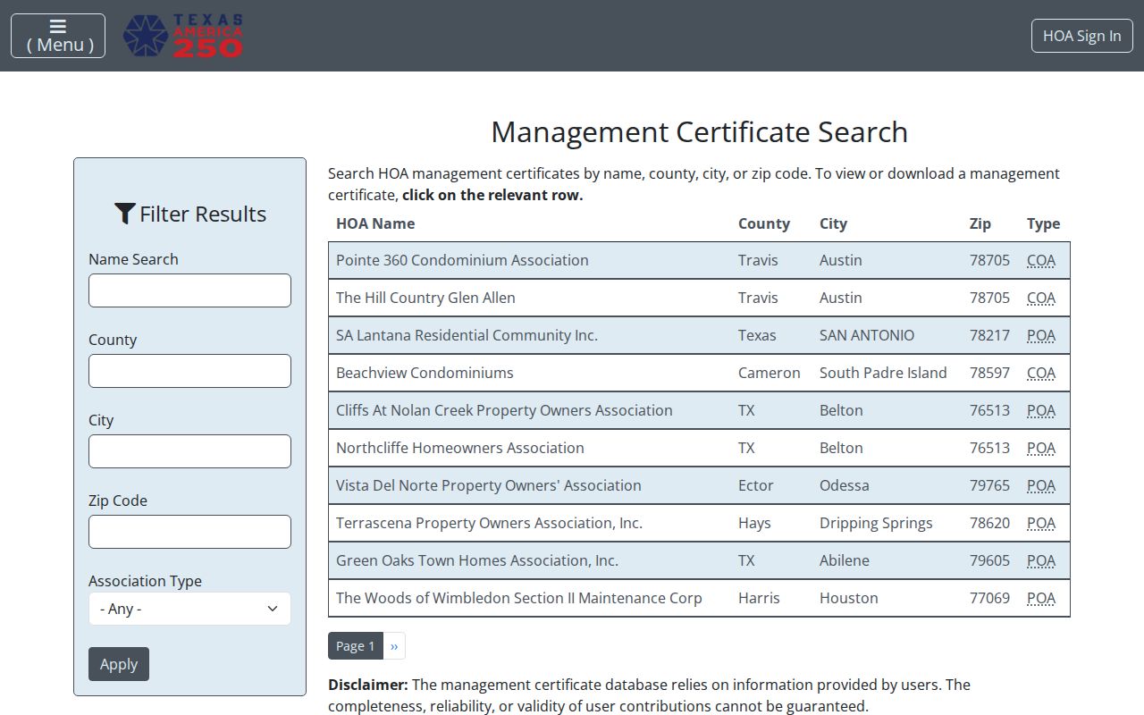
The Hightower value is a database-listed anomaly, not a replacement ZIP fact. Check the certificate, street, USPS result, TAD situs, and city map before relying on an association row.
Request Watauga ZIP Code Map Data
Tarrant Elections publishes ZIP and precinct interactive maps and accepts requests for maps, election results, and dated files. The state voter-registration check is for a matching voter’s status, not an address-to-person lookup. For a county request, use the Tarrant Elections public-information form and specify the smallest geography and year needed. The form includes precinct, district, or countywide choices and delivery fields.
Tarrant County Elections Administration is at 2700 Premier St, Fort Worth, TX 76111, phone 817-831-8683, with email at ElectionsInfo@tarrantcountytx.gov. The form lists email and FTP as no-charge delivery, a CD at $1, a mailed CD at $2.05, and paper at $.10 per page. Mail, email, in-person, and designated-records-contact routes are documented. GIS requests can go to 817-831-6160 or Elections--GIS@tarrantcountytx.gov. The Watauga Public Library can help with online state lookup access and election-history context, but it does not publish a voter file.
Texas Election Code §18.009 restricts commercial advertising use of voter information. Protected voter addresses and identifying information remain confidential. Use dated map or election records for lawful civic, family-history, or property-context research, never to assemble a contact list or harass anyone.
Keep Watauga ZIP Code Results Accurate
Watauga’s compact city sits in a wider Tarrant County records and postal landscape. A postal assignment can be correct while the city jurisdiction, tax mailing address, or association metadata differs. No official Watauga readdressing or street-renumbering project was located in the research. When an older number will not match, bridge through the parcel, plat, legal description, subdivision, adjacent streets, and a Watauga PIA request for a written city confirmation.
Use ZIP and address records for careful, lawful research. Do not repost protected voter fields, private utility data, or sensitive personal identifiers. If a property card, deed index, postal result, or municipal record is wrong, ask the record custodian for its correction process and retain the record number with the request.